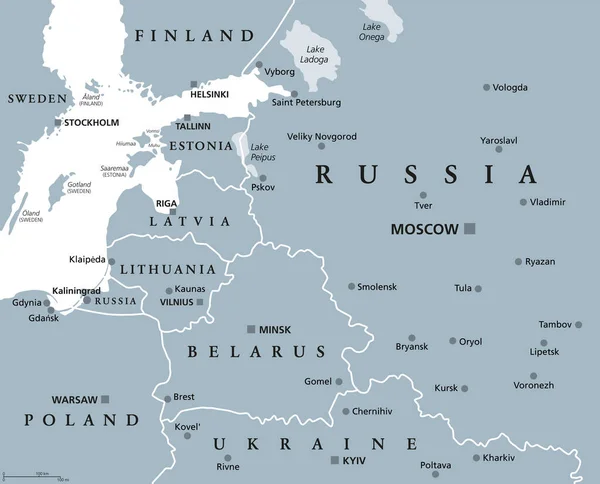
Baltic States and Kaliningrad Oblast, gray political map. From Finland to Estonia, Latvia and Lithuania to Poland, and from the Russian exclave Kaliningrad, to Belarus and the European Part of Russia.
Esta foto
Baltic States and Kaliningrad Oblast, gray political map. From Finland to Estonia, Latvia and Lithuania to Poland, and from the Russian exclave Kaliningrad, to Belarus and the European Part of Russia..
Datos de la Imágen (tiene derechos de autor*)
- Fotografía:
-
Baltic States and Kaliningrad Oblast, gray political map. From Finland to Estonia, Latvia and Lithuania to Poland, and from the Russian exclave Kaliningrad, to Belarus and the European Part of Russia.
- Autor:
- Ancho original:
-
7432 píxeles.
- Altura original:
-
6000 píxeles.
- Tamaño:
-
44.59 megapíxeles.
- Categorías:
-
- Palabras Clave:
-
gris Mar Báltico enclave Kaliningrado Finlandia europeo zona UCRANIA sujeto federal Polonia Países bálticos Atlas Gdynia Prusia Capital social Belarús cartografía Vilna Bálticos ESTOCOLMO LITUANIA geografía Europa del Este MOSCÚ ilustración Helsinki Escandinavia Konigsberg región mapa Báltico estado frontera Óblast de Países Bajos Ruso Kiev Riga Óblast de Kaliningrado Tallin Minsk país Gdansk Europa Mapa político RUSIA Letonia vector suecas .
Popularidad
- Vistas:
- 24
- Descargas:
- 2

Fotos similares
Otros temas con fotografías que le puede interesar
- sujeto federal
- Estado
- Letonia
- LITUANIA
- zona
- suecas
- Gdansk
- europeo
- Bálticos
- cartografía
- Atlas
- Óblast de
- mapa
- Polonia
- ilustración
- Kaliningrado
- MOSCÚ
- geografía
- Europa
- Mar Báltico
- Escandinavia
- gris
- Finlandia
- Kiev
- Tallin
- RUSIA
- frontera
- Minsk
- Prusia
- enclave
- Países Bajos
- vector
- país
- Konigsberg
- Ruso
- Países bálticos
- región
- Mapa político
- Helsinki
- Belarús
- Óblast de Kaliningrado
- ESTOCOLMO
- Riga
- Vilna
- Gdynia
- UCRANIA
- Europa del Este
- Capital social
- Báltico
(*) Sitio para adquirir: Link externo para Comprar
Fotografía de Baltic States and Kaliningrad Oblast, gray political map. From Finland to Estonia, Latvia and Lithuania to Poland, and from the Russian exclave Kaliningrad, to Belarus and the European Part of Russia., que incluye Baltic States and Kaliningrad Oblast, gray political map. From Finland to Estonia, Latvia and Lithuania to Poland, and from the Russian exclave Kaliningrad, to Belarus and the European Part of Russia..
Todas las imágenes por Depositphotos