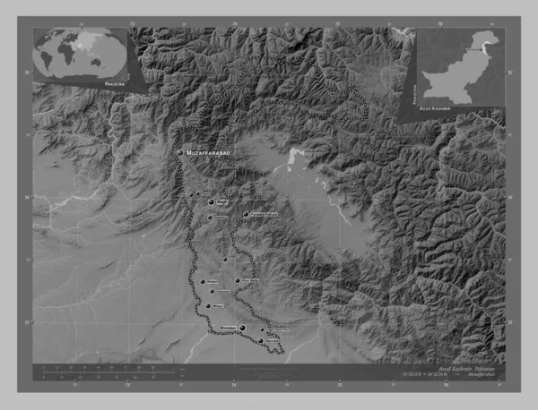
Azad Kashmir, centrally administered area of Pakistan. Grayscale elevation map with lakes and rivers. Locations and names of major cities of the region. Corner auxiliary location maps
Esta foto
Azad Kashmir, centrally administered area of Pakistan. Grayscale elevation map with lakes and rivers. Locations and names of major cities of the region. Corner auxiliary location maps.
Datos de la Imágen (tiene derechos de autor*)
- Fotografía:
-
Azad Kashmir, centrally administered area of Pakistan. Grayscale elevation map with lakes and rivers. Locations and names of major cities of the region. Corner auxiliary location maps
- Autor:
- Ancho original:
-
4930 píxeles.
- Altura original:
-
3770 píxeles.
- Tamaño:
-
18.59 megapíxeles.
- Categorías:
-
- Palabras Clave:
-
Mirpur forward kahuta Pak planeta Asia dhirkot Atlas región Ciencia tierra Capital social frontera Rango khui ratta área administrada centralmente Continente Naturaleza contorno bhimber chakswari cachemira azad Muzaffarabad Pakistán rawalakot división administrativa Leyenda barnala geografía Zoom: Bagh país océano Islamabad Tierras Territorio dadyal Kotli esquema estereográfico mapa mundo forma amgah paanch peer .
Popularidad
- Vistas:
- 0
- Descargas:
- 0

Fotos similares
Otros temas con fotografías que le puede interesar
- Pakistán
- Capital social
- Leyenda
- dadyal
- planeta
- Continente
- mundo
- forma
- contorno
- frontera
- Muzaffarabad
- Kotli
- Zoom:
- país
- océano
- barnala
- esquema
- cachemira azad
- Naturaleza
- Bagh
- Rango
- khui ratta
- estereográfico
- amgah paanch peer
- dhirkot
- región
- Islamabad
- Atlas
- Mirpur
- Tierras
- forward kahuta
- chakswari
- división administrativa
- Territorio
- área administrada centralmente
- mapa
- rawalakot
- Pak
- bhimber
- tierra
- geografía
- Ciencia
- Asia
(*) Sitio para adquirir: Link externo para Comprar
Fotografía de Azad Kashmir, centrally administered area of Pakistan. Grayscale elevation map with lakes and rivers. Locations and names of major cities of the region. Corner auxiliary location maps, que incluye Azad Kashmir, centrally administered area of Pakistan. Grayscale elevation map with lakes and rivers. Locations and names of major cities of the region. Corner auxiliary location maps.
Todas las imágenes por Depositphotos