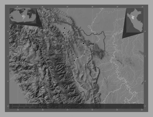
San Martin, region of Peru. Bilevel elevation map with lakes and rivers. Locations of major cities of the region. Corner auxiliary location maps
Esta foto
San Martin, region of Peru. Bilevel elevation map with lakes and rivers. Locations of major cities of the region. Corner auxiliary location maps.
Datos de la Imágen (tiene derechos de autor*)
- Fotografía:
-
San Martin, region of Peru. Bilevel elevation map with lakes and rivers. Locations of major cities of the region. Corner auxiliary location maps
- Autor:
- Ancho original:
-
4930 píxeles.
- Altura original:
-
3770 píxeles.
- Tamaño:
-
18.59 megapíxeles.
- Categorías:
-
- Palabras Clave:
-
región huicungo país saposoa forma Ciencia Continente océano gold coast Australië uchiza frontera Zoom: Moyobamba perú geografía chazuta san roque de cumbaza barrio nuevo juanjui Tarapoto esquema división administrativa Territorio mapa contorno Capital social tierra Atlas América del Sur planeta bagazán mundo Lima Bellavista estereográfico Leyenda pueblo libre picota San Martín soritor Tierras Por Naturaleza .
Popularidad
- Vistas:
- 0
- Descargas:
- 0

Fotos similares
Otros temas con fotografías que le puede interesar
- Tierras
- Zoom:
- planeta
- pueblo libre
- Lima
- país
- mundo
- Ciencia
- Territorio
- Naturaleza
- perú
- forma
- océano
- división administrativa
- Atlas
- tierra
- mapa
- contorno
- gold coast Australië
- San Martín
- geografía
- estereográfico
- san roque de cumbaza
- huicungo
- barrio nuevo
- Bellavista
- Por
- Tarapoto
- Capital social
- frontera
- bagazán
- esquema
- juanjui
- Leyenda
- saposoa
- América del Sur
- Moyobamba
- chazuta
- región
- picota
- Continente
- soritor
- uchiza
(*) Sitio para adquirir: Link externo para Comprar
Fotografía de San Martin, region of Peru. Bilevel elevation map with lakes and rivers. Locations of major cities of the region. Corner auxiliary location maps, que incluye San Martin, region of Peru. Bilevel elevation map with lakes and rivers. Locations of major cities of the region. Corner auxiliary location maps.
Todas las imágenes por Depositphotos