Dolnoslaskie, voivodeship|province of Poland. Colored elevation map with lakes and rivers. Locations of major cities of the region. Corner auxiliary location maps
Esta foto
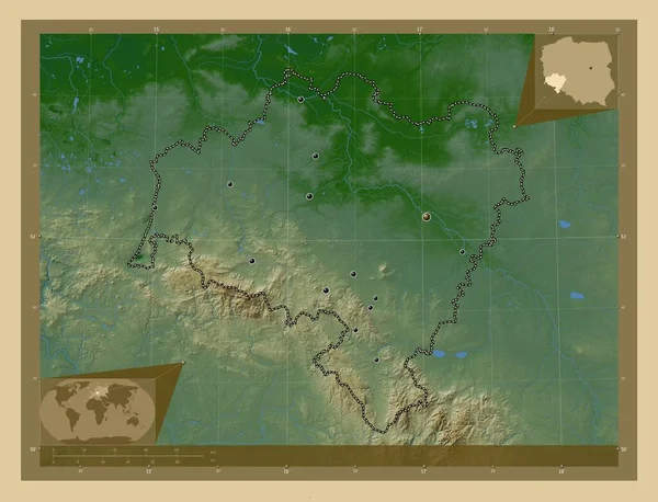
Dolnoslaskie, voivodeship|province of Poland. Colored elevation map with lakes and rivers. Locations of major cities of the region. Corner auxiliary location maps.
Datos de la Imágen (tiene derechos de autor*)
- Fotografía:
-
Dolnoslaskie, voivodeship|province of Poland. Colored elevation map with lakes and rivers. Locations of major cities of the region. Corner auxiliary location maps
- Autor:
- Ancho original:
-
4930 píxeles.
- Altura original:
-
3770 píxeles.
- Tamaño:
-
18.59 megapíxeles.
- Categorías:
-
- Palabras Clave:
-
Leyenda mundo esquema forma estereográfico Bielawa Lucien Capital social planeta Jelenia Gora división administrativa país región Ciencia Continente Naturaleza mapa Europa walbrzych Lubin Boleslawiec Zoom: voivodato Polonia POL Wroclaw Tierras contorno Olawa Swidnica Atlas Zgorzelec frontera océano tierra provincia Klodzko geografía Glogow Legnica Dolnoslaskie Territorio nowa ruda .
Popularidad
- Vistas:
- 0
- Descargas:
- 0

Fotos similares
Otros temas con fotografías que le puede interesar
- Zoom:
- walbrzych
- esquema
- geografía
- Europa
- mundo
- océano
- voivodato
- Continente
- contorno
- Capital social
- planeta
- forma
- nowa ruda
- Wroclaw
- Glogow
- división administrativa
- Naturaleza
- Ciencia
- estereográfico
- mapa
- Territorio
- Lucien
- provincia
- región
- Dolnoslaskie
- Tierras
- Atlas
- Boleslawiec
- tierra
- POL
- Swidnica
- Zgorzelec
- Jelenia Gora
- Olawa
- Legnica
- Leyenda
- frontera
- Bielawa
- Lubin
- Polonia
- país
- Klodzko
(*) Sitio para adquirir: Link externo para Comprar
Fotografía de Dolnoslaskie, voivodeship|province of Poland. Colored elevation map with lakes and rivers. Locations of major cities of the region. Corner auxiliary location maps, que incluye Dolnoslaskie, voivodeship|province of Poland. Colored elevation map with lakes and rivers. Locations of major cities of the region. Corner auxiliary location maps.
Todas las imágenes por Depositphotos