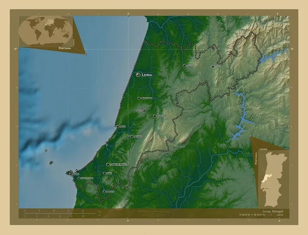
Leiria, district of Portugal. Colored elevation map with lakes and rivers. Locations and names of major cities of the region. Corner auxiliary location maps
Esta foto
Leiria, district of Portugal. Colored elevation map with lakes and rivers. Locations and names of major cities of the region. Corner auxiliary location maps.
Datos de la Im·gen (tiene derechos de autor*)
- FotografÌa:
Leiria, district of Portugal. Colored elevation map with lakes and rivers. Locations and names of major cities of the region. Corner auxiliary location maps
- Autor:
- Ancho original:
4930 pÌxeles.
- Altura original:
3770 pÌxeles.
- TamaÒo:
18.59 megapÌxeles.
- CategorÌas:
- Palabras Clave:
Portugal Leiria contorno Nazare Pombal Atlas esquema Lisboa mapa geografÌa Caldas da rainha Tierras prt Naturaleza frontera alcÛbaca Ciencia atouguia da baleia Territorio forma divisiÛn administrativa regiÛn Peniche Capital social estereogr·fico Leyenda Obidos ocÈano Maceira planeta tierra distrito Zoom: Continente Batalha mundo paÌs Bombarral Europa marinha grande .
Popularidad
- Vistas:
- 0
- Descargas:
- 0

Fotos similares
Otros temas con fotografÌas que le puede interesar
- esquema
- mundo
- Bombarral
- Maceira
- mapa
- Naturaleza
- ocÈano
- geografÌa
- divisiÛn administrativa
- Atlas
- Caldas da rainha
- tierra
- Leyenda
- Lisboa
- forma
- Capital social
- Peniche
- Europa
- Continente
- Territorio
- atouguia da baleia
- Leiria
- Batalha
- Obidos
- Portugal
- Zoom:
- prt
- Ciencia
- regiÛn
- Nazare
- marinha grande
- planeta
- distrito
- frontera
- Pombal
- Tierras
- paÌs
- contorno
- estereogr·fico
- alcÛbaca
(*) Sitio para adquirir: Link externo para Comprar
FotografÌa de Leiria, district of Portugal. Colored elevation map with lakes and rivers. Locations and names of major cities of the region. Corner auxiliary location maps, que incluye Leiria, district of Portugal. Colored elevation map with lakes and rivers. Locations and names of major cities of the region. Corner auxiliary location maps.
Todas las im·genes por Depositphotos