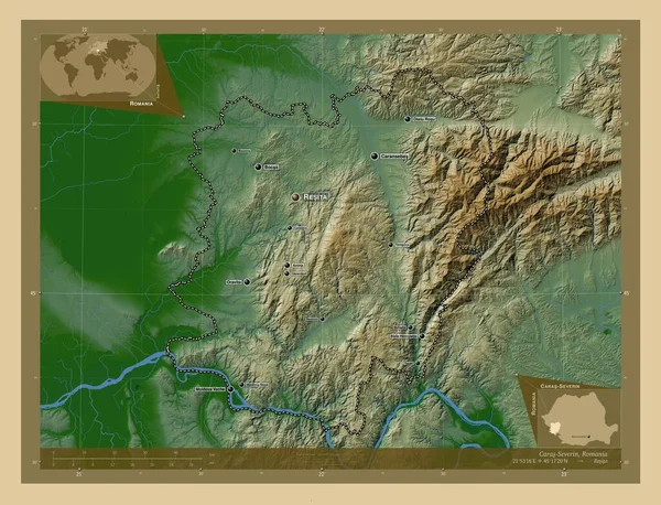
Caras-Severin, county of Romania. Colored elevation map with lakes and rivers. Locations and names of major cities of the region. Corner auxiliary location maps
Esta foto
Caras-Severin, county of Romania. Colored elevation map with lakes and rivers. Locations and names of major cities of the region. Corner auxiliary location maps.
Datos de la Imágen (tiene derechos de autor*)
- Fotografía:
-
Caras-Severin, county of Romania. Colored elevation map with lakes and rivers. Locations and names of major cities of the region. Corner auxiliary location maps
- Autor:
- Ancho original:
-
4930 píxeles.
- Altura original:
-
3770 píxeles.
- Tamaño:
-
18.59 megapíxeles.
- Categorías:
-
- Palabras Clave:
-
Continente provincia Atlas toplet esquema Baile herculano teregova forma tierra Capital social región estereográfico Resita mapa berzovia frontera Naturaleza planeta contorno Europa Otelu rosu océano Territorio steierdorf bozovici geografía Zoom: Leyenda moldova noua mundo Caransebes Oravita carasova Bucarest BOCSA Rumanía carillas severina Anina Rou Ciencia Tierras división administrativa país Moldavia Veche .
Popularidad
- Vistas:
- 1
- Descargas:
- 0

Fotos similares
Otros temas con fotografías que le puede interesar
- Territorio
- berzovia
- Caransebes
- Oravita
- Resita
- Tierras
- mundo
- Continente
- Rou
- forma
- Atlas
- Ciencia
- geografía
- provincia
- teregova
- moldova noua
- esquema
- carasova
- BOCSA
- Europa
- tierra
- estereográfico
- Rumanía
- Leyenda
- Anina
- carillas severina
- contorno
- bozovici
- océano
- frontera
- Zoom:
- Capital social
- planeta
- toplet
- región
- país
- mapa
- Baile herculano
- Bucarest
- división administrativa
- Otelu rosu
- steierdorf
- Naturaleza
- Moldavia Veche
(*) Sitio para adquirir: Link externo para Comprar
Fotografía de Caras-Severin, county of Romania. Colored elevation map with lakes and rivers. Locations and names of major cities of the region. Corner auxiliary location maps, que incluye Caras-Severin, county of Romania. Colored elevation map with lakes and rivers. Locations and names of major cities of the region. Corner auxiliary location maps.
Todas las imágenes por Depositphotos